Storm Prediction Center upgrades chance for supercell tornado activity
The National Weather Service/NOAA Storm Prediction Center has upgraded the chance to a 4 out of 5 that our area receives severe weather including supercell tornado activity.
From the Prediction Center:
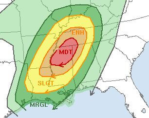
RAP forecast soundings across the Moderate Risk area from    north-central Mississippi into southwest Tennessee at 21Z show    moderate instability and impressive kinematic profiles. MLCAPE is    forecast to be from 1000 to 1200 J/kg with 0-6 km shear in the 50 to    55 kt range. This will support supercell formation with cells that    remain discrete. In addition, hodographs are long and looped with    0-3 km storm relative helicity values in the 350 to 450 m2/s2 range.    This low-level shear environment will be favorable for tornadoes.

A    potential for long-track significant tornadoes will exist across the    Moderate Risk area from late this morning through much of the    afternoon. Wind damage and isolated large hail will also be possible    with supercells. A squall-line is also expected to develop and move    across the Enhanced and Moderate risk areas during the late    afternoon and early evening. Wind damage, isolated large hail and a    few tornadoes will also be possible with the stronger thunderstorms    embedded in the line. This squall-line with wind damage potential    should move across middle Tennessee and north-central Alabama during    the evening.


