Hurricane Isaias Morning Update: Storm to Strengthen Before Friday Gulf Coast Landfall, Inland Mississippi Faces Heavy Rain
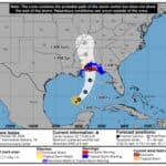
The National Hurricane Center’s early-morning update on Hurricane Isaias carries a clear message for Mississippi: while impacts are expected along the coast starting Friday, gusty winds, heavy rain and flash flooding are possible further inland across the state.
Here are the key messages from the NHC’s Advisory 7, issued at 4:00 a.m. CDT Thursday, Oct. 8:
- Strengthening storm: Isaias is expected to strengthen and be a strong hurricane when it approaches the northern Gulf Coast on Friday. A life-threatening storm surge is expected along a portion of the northern Gulf Coast, and a Storm Surge Warning remains in effect from the Mouth of the Mississippi River to Steinhatchee, Florida. Residents in the warning area should follow advice from local officials and evacuate if told to do so.
- Damaging winds: Damaging hurricane-force winds are expected over portions of the Florida Panhandle, southern Alabama, and southern Mississippi, and a Hurricane Warning remains in effect from Ocean Springs, Mississippi to the Bay/Gulf County Line, Florida. Residents in these areas should prepare for the possibility of long-duration power outages.
- Heavy rain: Isaias will bring areas of heavy rainfall to the central U.S. Gulf coast and much of the Southeast Friday into the weekend. Flash and urban flooding, along with isolated river flooding, will be possible.
Time to Prepare Is Now
If you haven’t already done so, the time to prepare is now. The Mississippi Department of Transportation offers free hurricane preparation resources at GoMDOT.com/Hurricanes.
For live road conditions in your area, download the MDOT Traffic App (available in the App Store and Google Play) or visit MDOTtraffic.com.
Stay tuned to local forecasts as the storm moves closer, and follow updates from the National Hurricane Center at hurricanes.gov.