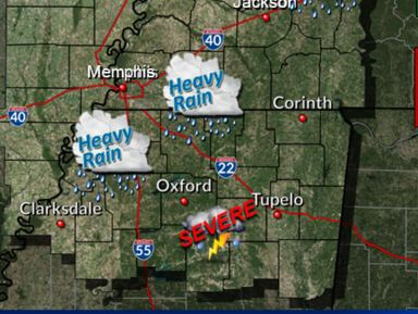
More severe weather on the way with some models showing up to 8 more inches of rain
With several roads being covered with water already and flood warnings in place, some models are calling for even more rain on the way.
From the NWS:
Thursday through Tuesday A Flash Flood Watch is in effect from Thursday afternoon through Saturday evening for areas along and south of the I-40 corridor. Multiple rounds of heavy rain will result in an additional 2-4 inches of rainfall. This will likely lead to flooding, rises in area rivers, and an increased potential for river flooding. A strong cold front will move across the area on Saturday. A few strong to severe thunderstorms are possible with damaging winds as the main threat.
This comes on the heels of some roads already experiencing major flooding throughout the area.
Be on the watch for severe weather in our area.


