Tippah County included in Flood Watch as more rain expected in area
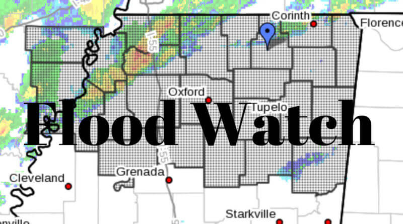
Tippah County and much of North Mississippi is under a flood watch as more rain is expected in the area.
From the NWS, the following areas are at risk:
Lee AR-Phillips-DeSoto-Marshall-Benton MS-Tippah-Alcorn-Tishomingo-
Tunica-Tate-Prentiss-Coahoma-Quitman-Panola-Lafayette-Union-Pontotoc-
Lee MS-Itawamba-Tallahatchie-Yalobusha-Calhoun-Chickasaw-Monroe-
Including the cities of Amory, Holly Springs, Pontotoc, Marks,
Senatobia, Southaven, Coffeeville, Bruce, Ripley MS, West Helena,
Aberdeen, Oxford, Batesville, Water Valley, Iuka, Booneville,
Corinth, Calhoun City, Ashland, Charleston, Okolona, Olive Branch,
Fulton, New Albany, Houston, Marianna, Tunica, Tupelo, Helena, and
Clarksdale
212 PM CST Tue Feb 22 2022
…FLOOD WATCH IN EFFECT THROUGH LATE TONIGHT…
* WHAT…Flooding caused by excessive rainfall is possible.
* WHERE…Portions of East Arkansas and North Mississippi, including
the following areas, in East Arkansas, Lee AR and Phillips. In
North Mississippi, Alcorn, Benton MS, Calhoun, Chickasaw, Coahoma,
DeSoto, Itawamba, Lafayette, Lee MS, Marshall, Monroe, Panola,
Pontotoc, Prentiss, Quitman, Tallahatchie, Tate, Tippah,
Tishomingo, Tunica, Union and Yalobusha.
* WHEN…Through late tonight.
* IMPACTS…Excessive runoff may result in flooding of rivers,
creeks, streams, and other low-lying and flood-prone locations.
Creeks and streams may rise out of their banks.
* ADDITIONAL DETAILS…
– http://www.weather.gov/safety/flood
PRECAUTIONARY/PREPAREDNESS ACTIONS…
You should monitor later forecasts and be alert for possible Flood
Warnings. Those living in areas prone to flooding should be prepared
to take action should flooding develop.
