Isaias is now a hurricane, and forecasters say its remnants will sweep across Tippah and Benton counties on Saturday. The Hurricane Isaias Tippah County outlook from the National Weather Service in Memphis calls for 2 to 3 inches of rain and wind gusts up to 40 mph in the Ripley area, with the heaviest weather from Saturday morning into Saturday night.
Until then, the weather will stay sunny, dry, and unusually warm, with highs near 88 to 89 on Thursday and Friday.
Where Hurricane Isaias Is Now
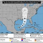
As of 7 a.m. CDT Thursday, the National Hurricane Center placed Isaias about 385 miles south-southwest of the mouth of the Mississippi River, moving east-northeast at 9 mph. Maximum sustained winds were near 80 mph, making it a Category 1 hurricane, and Hurricane Hunter aircraft were investigating the storm.
The hurricane center expects Isaias to strengthen through early Friday, turn north, and make landfall along the northern Gulf Coast late Friday or early Saturday. Current coastal alerts include:
Hurricane Warning: Ocean Springs, Miss., to the Bay/Gulf County line in Florida
Tropical Storm Warning: the Jefferson/Plaquemines Parish line in Louisiana to west of Ocean Springs, and parts of the Florida Panhandle
Storm Surge Warning: the mouth of the Mississippi River to the Steinhatchee River, Fla., with 5 to 7 feet of surge possible from Ocean Springs to Indian Pass and in Mobile Bay
Hurricane Isaias Tippah County Forecast for Saturday
The latest NWS point forecast for Ripley shows:
Friday night: A 30% chance of showers after 1 a.m.; low around 63.
Saturday: Rain before 1 p.m., then showers and thunderstorms. High near 71, falling into the upper 60s in the afternoon. East-northeast winds of 10 to 20 mph with gusts as high as 40 mph. Rain chance 90%, with 2 to 3 inches possible.
Saturday night: Showers and storms continue, with gusts to 35 mph and another three-quarters of an inch to 1 inch of rain.
Sunday: A few early showers, then partly sunny with a high near 75.
In its Thursday morning forecast discussion, NWS Memphis said total rainfall across the Mid-South should generally run 1 to 3 inches, with local amounts up to 4 inches over northeast Mississippi and near the Tennessee River. Forecasters said the ground is dry from drought, but that will not completely remove the flooding risk if rain falls hard and fast. No Flood Watch has been issued yet, but the office said one may be considered in later forecasts.
The weather service said a brief tornado cannot be ruled out, though the area with the greatest tornado risk is expected to stay east of the Tennessee River. The rain should move out early Sunday, with dry, warm weather returning by the middle of next week.
How to Prepare
The Mississippi Emergency Management Agency has urged residents across the state to get ready for heavy rain and gusty winds this weekend, according to TVMO Community News. MEMA’s advice includes checking emergency supplies, with at least three days of drinking water and non-perishable food for each household member, plus medications, a first-aid kit, flashlights, batteries, and important documents. The agency also recommends fully charging cell phones and portable battery packs before the storm arrives.
Other common-sense steps before Saturday:
Bring in or tie down trampolines, patio furniture, and anything else the wind could toss.
Clear gutters and storm drains near your home.
Never drive through water over the road: “Turn Around, Don’t Drown.”
Football games and outdoor events scheduled for Saturday could be affected, so check with organizers before heading out. Tippah County’s outdoor burn ban is set to run through Oct. 18, and supervisors plan to decide on any extension at their Oct. 15 meeting.
Jon Ross Myers is the executive editor and publisher of the Mississippi News Network, Mississippi's largest digital only media company. He can be reached at editor@tippahnews.com