The National Weather Service has signaled the chance for severe weather on Monday.
The greatest risk is around the late morning to early afternoon for severe weather.
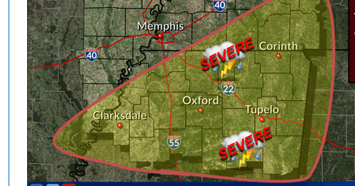
From the NWS:
A few severe storms are possible Monday along and south of a line from Helena-West Helena, Arkansas to Bolivar, Tennessee to Decaturville, Tennessee. The best chance for severe weather will be across north-central and northeast Mississippi Monday afternoon into the early evening. Damaging winds will be the main threat. A tornado is possible along with large hail.
Showers and possibly a thunderstorm before noon, then showers and thunderstorms after noon. Temperature rising to near 64 by noon, then falling to around 49 during the remainder of the day. South southwest wind 5 to 10 mph becoming west northwest in the afternoon. Chance of precipitation is 100%. New rainfall amounts between three quarters and one inch possible.
Jon Ross Myers is the executive editor and publisher of the Mississippi News Network, Mississippi's largest digital only media company. He can be reached at editor@tippahnews.com